Wednesday, March 29, 2023

Days 5-7: Heading East


 On Monday morning, we packed as soon as we got up, so that we’d be ready to leave when we finished breakfast. We stopped briefly to fill up the car, and were headed east to Capitol Reef National park by 10:00 am, driving along UT 12, often called “the most scenic road in the US.”

I’m not sure that is correct, but it certainly is scenic. Just before the town of Escalante, we pulled off at the Escalante Petrified Forest State Park for lunch and a hike. The 1.2 mile hike climbs to the top of the mesa and looks out over the town of Escalante.


I should have learned my lesson earlier. The hike was marked easy-moderate, but I was huffing and puffing as we reached the Escalante overlook.


There wasn’t as much petrified wood as in the Petrified Forest National Monument in Arizona. But the pieces we saw were striking.


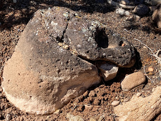
There were also some unique rounded black rocks from the Boulder Mountain volcano just to the north. I liked this one which looks like a dinosaur head eating a wedge of cheese. After our hike we finished up the last of our sandwiches at the picnic area.


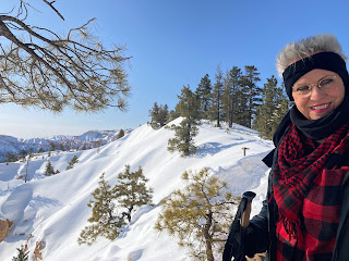
Heading north to the town of Torrey, we crossed over Boulder Mountain, where the snow piled at the side of the road was often higher than our car. We pulled out at the summit and I took this picture, looking east towards Colorado.


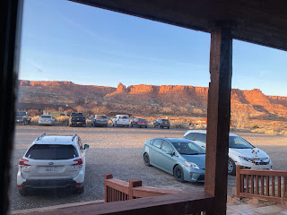
We arrived in Torrey at our hotel, the Rim Rock Inn, about 5:30. This is a classic road-trip motel, right under the red-rock-cliff mesa which borders Capitol Reef. The late-afternoon sun on the rim-rock was awesome. We had dinner at the motel restaurant, because we were too tired to get in the car and drive into town. It turned out to be a great decision. 


When the sun went down at 7:45 we closed our drapes on the view and fell, exhausted, to sleep.

Capital Reef to Arches

On Tuesday, we walked across the highway for breakfast at the Pioneer Inn, where we had an inexpensive meal, and Kathy took a video of a family embarking on a hike with a group of llamas. Leaving the motel we stopped to gas up our car, and then headed east to Capitol Reef National Park.


Capitol Reef is a long, narrow park, starting at Cathedral Valley in the north, and traveling south following  a geological ridge called the Waterpocket Fold, where it ends in the Hall’s Creek Narrows in Glen Canyon (north Lake Powell).


The most accessible region of the park is centered around the Mormon Pioneer town of Fruita. From there, you can drive south along a 20-mile scenic drive that ends in a dirt road at Capitol Gorge.


We drove four or five miles down the road, took some pictures, and then turned around.


The views at the bottom of the canyons were really awe inspiring.


On the way out of the park, we stopped at the Gifford House. This is the original homestead in Fruita (where they didn’t have electricity until the 1940s). Now, it has been restored by the Park Service, and it sells traditional homemade pies and ice cream.


We left Capitol Reef and headed northeast to Moab, Utah, where we arrived at 3pm. Since it was sunny, and still early, we decided to visit Arches National park, since it was right outside of town. We’re glad we did. There was no line, the light was beautiful, and the park was uncrowded. That’s Balanced Rock behind Kathy and I.


We drove to the Windows area and hiked up to the three arches, North Window, South Window and Turret Arch. It’s hard to appreciate how immense these arches are. Notice Kathy in the picture above, and then…


…look how small she appears when she’s right under the arch.


At the top, we met a fellow from New Jersey, who took our picture with both the North and South Window arches.


Besides the arches there were so many fantastical shapes. Kathy would say “that looks just like a Greek temple,”  and I’d see a different formation, and say, “that looks just like a dwarf pushing a shopping cart.”


We left the park after sunset, both of us bone-weary, but really pleased with our late-afternoon adventure.

Wednesday in Canyonlands

Wednesday dawned gray and overcast, so we were doubly glad that we had visited Arches last night. We took our time getting up, and stopped at Canyon Steak and Waffle for breakfast.


Both of us had the Southwest Breakfast Bowl. It was inexpensive and delicious.


After breakfast we drove northeast to Canyonlands National Park. Canyonlands and Arches are on either side of the highway leading into Moab.


Like Capitol Reef, Canyonlands consists of several different areas, and most of the park is inaccessible to  passenger-car traffic. The northern section, Island in the Sky, is on top of the 20-mile-long mesa overlooking the confluence of the Colorado and Green rivers. 


The two sides of the plateau have very different geologies. The Green River side is not as steep and eroded, while the Colorado side is extremely rugged.


At the end of the scenic drive, you can look out and see where both rivers join. There is a southern part of the park, called the Needles region, that is immediately adjacent to the confluence, but it is quite a ways off of the highway, so we’ll probably skip it.


The park was pretty crowded (for March), and at a couple of the vista points, we couldn’t get a parking spot. We drove out to Whale Rock at one branch of the scenic drive, and found the parking lot for the Upheaval Dome trail completely full, with people parking on the highway. So, we didn’t stop.


On the way out of the park, at the Mesa Arch parking lot, one of my “must-see” sights, we saw an empty space and pulled in.


There is an easy, one-mile (round trip) trail out to the arch, which can’t be seen from the road. 


The arch itself is much smaller than those in Arches National Park, but, being right on the edge of the cliff, it is very picturesque, and quite photographed (often with the moon rising through the arch).


We left the park listening to a Preston and Childs book about the Donner Party, which I checked out from the library. Early on the trip, we listened to Thunderhead, a book about the discovery of a lost Anasazi city called Quivira. It was especially cool, since the book was talking about the canyons and cities that we were driving through.


We got back to Moab around 2:30 pm and decided to have a big lunch and skip dinner. We went to Arches Thai and had Pad Thai, Tom Kha soup, tempura vegetables and so Thai pork fried rice. We only ate half of  it and saved the rest for dinner.

I’m sure you noticed, I haven’t kept up with a blog entry every day. One reason is because we didn’t have a chair or desk in our motel room. So after lunch we went looking for a Starbucks, where I could catch up. The only Starbucks was in a grocery store (with no seating), so, instead, we walked two blocks to MacDonalds, and spent the rest of the afternoon typing. 

It’s 6:00 pm now, and in the morning, we’ll leave the five National Parks of Utah and head south into the Navaho Nation Monument Valley park. 

Monday, March 27, 2023

Day 4: Bryce & Friends

We woke up around 7:30 in the morning. I see a trend developing. I’m sure tomorrow we’ll wake up at 8:00AM. We had breakfast in the hotel buffet. It was good, but we’d been spoiled the last two days at Oscar’s and Porters. After a quick trip back to the room, we were ready to revisit Bryce on this sunny morning.


Our first stop was across the highway at Ruby’s Inn, a combination hotel, Cowboy Buffet & Steak House, adventure sports booking agency, general store, and the center around which almost all activities in the Bryce area spin. Although it had not snowed overnight, our windshield was covered with a thick layer of ice, and I needed to pick up an ice scraper as well as some sunscreen.


Once we could see out of the front window, we set off for Sunrise Point, the only view point we hadn’t visited yesterday, because of the snowy trail. Before we left home, we purchased some ingenious traction devices to slip over our shoes, so we could walk on ice. They look something like the Yaktrax devices, but are actually half-price no-name knock-offs, so I was a little apprehensive.


I needn’t have worried. When we get to Sunrise Point we pulled them on and headed up the snowy trail for the canyon rim, and the traction devices worked great. Yesterday, we felt really unsteady, and ready to slip, but these clung to the snow like Velcro. (Maybe not; I guess that Velcro would be really slippery on snow, but I think you get the idea.)


Kathy picked up a pair of hiking sticks from Costco before we left, and we each used one. It helped our stability even more. As you can see, the sun was just perfect for Sunrise Point. 
 

As we were standing there, looking out over the basin, a Blue Jay landed in the tree right above my head and started singing (or whatever Blue Jay’s do.)


Looking down into the basin, we could see all of the hoodoos topped with snow. Now that we felt more comfortable, we climbed the hill to the Sunrise Point overlook where we met a group of five MIT graduate students studying energy policy and technology. They were also on spring break.


They had flown out to Las Vegas,  rented an RV, and were visiting the Utah parks and the Grand Canyon. They were an eclectic group with one Australian, a young lady from the Netherlands, one Californian, a Frenchman, and a German. We took a group photo for them, and they returned the favor for Kathy and I.


Walking further along the rim we came to Inspiration Point. We had driven here yesterday, but hadn’t felt comfortable walking out to the viewpoint. By this time, the clouds were coming in, and it was really impressive as the sun spotlighted different parts of the canyon.


Here’s an old tree stump at Inspiration Point that inspired me.


We finished up our morning by driving back to Bryce Point where we were able to walk up to the top and look around. Behind us you can see the sun and clouds lighting up the different parts of the canyon.


It was getting near lunch time, and we had visited all of the trails that were open in the park, except for the Queen’s Garden trail, a short loop down into the canyon, which neither of us felt like taking. My legs were getting a little sore. Even with the traction on my shoes, I found myself tensing up. We decided on the back to the hotel to spend the afternoon on a road trip in the area around Bryce. We packed some food and headed out around 1:00 PM.


Our first stop was the Mossy Cave, about 5 miles east of Bryce (although technically still inside the park). We got the last spot in the parking lot and headed up the trail, amidst the red rock cliffs. We met a couple of ladies on the trail, who showed us how to remove the rubber tip on our walking sticks to get a better purchase on the icy trail.


In the winter, the Mossy Cave is mossy no longer. All of the drippings are converted to icicles. It looks like a freeze-frame of a waterfall. The ladies from Wisconsin took our picture and we took theirs.

After our hike, we got back in the car and drove south through the towns of Tropic (where I got gas at $3.99 a gallon) and Cannonville where we turned off to visit Kodachrome Basin State Park. Our National Parks pass wasn’t good here, so we paid ten dollars to drive up through the park. 

It was snowing now, so we sat and watched the snow and the hoodoos in our car as we ate our lunch. On the way back to our hotel, the snow got so heavy that all we could see was white in every direction. It was pretty disorienting and I slowed down to about 25 miles per hour.

Back in Bryce City, we stopped at Ruby’s Cowboy Buffet and Steak House for dinner. The food was OK, but nothing to write home about. We turned in before 8:00 PM.

In the morning, we’re off to Capitol Reef.

Sunday, March 26, 2023

Day 3: Zion to Bryce


Saturday morning, and we’re getting a little more into vacation mode; we slept in until 7:00 AM, took our time getting ready and then went out to breakfast around 9:00 AM. Our B&B vouchers were good for two different restaurants, so this morning we went over to Porters, directly across the street from the Novel House. 


I had a huge chicken-fried steak with eggs, potatoes and toast, and Kathy had a Popeye omelette. They didn’t have decaf though, so I had to make do with Chamomile tea, something I haven’t had for fifty years. 


After breakfast, we went back to our room and finished packing, checking out right at the 11:00 AM deadline. Leaving the park entrance, we drove east towards Bryce. When we had the opportunity, we pulled over to stretch our legs and take some pictures. 


Just a few miles after the entrance, we saw the “blind” arch on the north side of the highway.


Then, switchbacking up the hill, we entered the 1930s Zion-Mt. Carmel tunnel. 


This one-mile-long tunnel has several window cut-outs looking out over Zion. You can’t stop at all in the tunnel, though, and the road is so narrow (by our modern standards), that I couldn’t even snatch a peek. I understand that if you drive an RV, you have to have a ranger escort to drive you through the tunnel.


On the other side, we stopped just past the Canyon Overlook trailhead (which was jammed). We met a nice couple from Washington and we took turns taking pictures. A little further on, we stopped at the Checkerboard Mesa turnout and got a few more pictures. It’s nice driving a little and then stopping and walking around.


At the Mt. Carmel Junction we turned north on Highway 89 and stoped at the little town of Oderville to buy some pickles and bread for our sandwiches. A few miles further north, in the town of Glendale, we tried to stop at the Grand Escalante Staircase visitor’s center, but it was closed until May. Instead, we stopped at the City Park and ate our lunch, watching as two students in a “master-gardener” class learned how to prune fruit trees. Apparently this is quite an event because there were ten or fifteen other people sitting around watching them.


Our hotel in Bryce had said that we couldn’t check in until 4:00 pm. Since it was only about 2:00 pm, we pulled off the road at Red Canyon and took a short walk up to the hill to some of the impressive “hoodoos” that were close to the road.


Even the short trail was icy and muddy and both of us were a little frightened of falling, so we didn’t climb any higher into the park. Instead we got back into our car and headed for our hotel, The Best Western Grand at Bryce Canyon.

Fortunately, there was no problem checking into our hotel early. After unpacking everything (afraid that our sodas would freeze if we left them in the car overnight), we decided to take advantage of the sunlight to see what we could. (We learned our lesson at Zion.)


When we drove into the park, the Visitor’s center was just closing (at 4:00 PM), but we did find out that the southern scenic drive was closed. I was a little disappointed, since I had mentally underlined the different stops and hikes for the next couple days.


Our first stop was Bryce Point, which was as far as the road was opened. I suppose one advantage of the cold weather is that it was easy to find a parking place. I remember Yellowstone and Glacier parks in the summer, when it was almost impossible to find parking at the popular trailheads, no matter how early we started out. 


The other advantage of the weather is that the views were really spectacular, even though we stayed at the cleared area in front of the parking lot, and didn’t walk up to Bryce Point itself. If the weather is good in the morning, we’ll pull our Yactrax knockoffs over our shoes and head up the snowy trail. For today, though, we’re taking it easy.


Back in the car, our next stop was Sunset Point. There was a nice parking lot there, with restrooms and a cleared path out to the viewing area. We met a couple from St. George, took their picture and they took ours. When we told them we were from Newport Beach, they told us they were leaving next week to spend time with friends in Corona Del Mar.


Our last stop was Inspiration Point, just as the sun was going down. Since it was 8:00 PM, we were too tired to go out to dinner, so we went back to our room and had some sandwiches. I tried to watch a movie on HBO or Cinemax, and gave up after fifteen minutes. Instead, I read one of Stephen Hunter’s books on my phone, until it fell from my fingers onto my chest, and I turned out the light.